-

Patiwat Sa-angchai replied to the topic Zipping and Extracting in the forum QGIS 8 months, 1 week ago
Hi Aung
from your problem you can follow this
1. Right-click on the layer that is not displaying, then choose “Repair Data Source” to point it to the correct file location.
2. Go to Project > Properties > General, and check or adjust the “Save paths” setting. If your files have been moved, make sure it’s set to “Relative” only if the folder stru…[Read more] -
Patiwat Sa-angchai replied to the topic QGIS version (Mac vs Window) in the forum QGIS 8 months, 2 weeks ago
Hi Aung, nice to meet you!
Thanks for sharing your experience — I’ve seen similar reports from other macOS users.This is actually a known issue on macOS. There have been bug reports that QGIS project files (especially .qgz) sometimes cannot be opened directly by double-clicking from Finder. However, if you open the project from within QGIS its…[Read more]
-
Patiwat Sa-angchai replied to the topic Teerawat_WK2: Clarification Needed on Handling NULL Values in Assignment 2.4 in the forum Archive Issues 1 year, 8 months ago
Hi Teerawat,
Yes “null” value cannot be display on map and in the example also have it. You will notice that we put the other layer under the prevalence layer to makes displayed correctly (it’s grey on map).
-
Patiwat Sa-angchai replied to the topic Nichcha (Wk2): Detailed screenshot and 2015.csv file issue in the forum Archive Issues 1 year, 8 months ago
Hello Nichcha ans Teerawat
For this assignment total malaria column is not necessary in this assignment and not use in the scoring method. don’t wary on this column once the data table can connect to spatial data correctly(every village point has their own cases data).
anyway if you need to calculate it you can done by field calculator.
-
Patiwat Sa-angchai replied to the topic I'm confused in the forum QGIS 2 years, 7 months ago
Sorry for my mistake that not properly change the file name to “Malaria_Village_incidence.shp”.
and yes we’ll use “Malaria_Village_incidence.shp” as a point data for intersection. -
Patiwat Sa-angchai replied to the topic Week 4 Assignment in the forum QGIS 2 years, 7 months ago
save selected feature is not the purpose of intersection method, even they result the same as intersecting point feature with polygon layer.
if you intersecting polygon or line as a input layer with polygon as a Intersect feature(cookie cutter) the result will difference. Save selected feature don’t change boundary of polygon or line but the…[Read more]
-
Patiwat Sa-angchai replied to the topic on-the-fly projection in the forum General Issues 2 years, 8 months ago
No need for those setting QGIS already done On the fly for you once the feature was load to project. if you need the Meter measurment for this step try to working with feature in UTM coordinate reference system that already measure the map in meter unit.
-
Patiwat Sa-angchai replied to the topic Week 3 Assignment in the forum QGIS 2 years, 8 months ago
Can you please upload the capture screen of your work to google drive and reply to me with that link? I cannot figure out the problem you facing now because I can settup it properly on mine.
about the size of the map Please try setting up the map sacle to 5,500,000 on map item properties(in main properties of map item). the map become smaller…[Read more]
-
Patiwat Sa-angchai replied to the topic .CSV data in the forum QGIS 2 years, 8 months ago
Some picture in the practical file might be slighly difference because sometime we setup the hold project befor capture the screen. Not to warry you will set is column up in next tutorial.
-
Patiwat Sa-angchai replied to the topic Submit assignment1 in the forum QGIS 2 years, 8 months ago
For uploading project file
To send the project all you need is to send .QGZ of your project within the zip file. The rest of component we will connect it to our file to preview your result compare with your screenshot, no need for all of the raw data you downloaded.For precision of population layer
This precision number use to…[Read more] -
Patiwat Sa-angchai replied to the topic SHP files in the forum APMEN VCWG Introductory GIS online training course 3 years, 7 months ago
Hello Jonard Chu
For the free Administrative boundary of the Philippines I found some free online data here.
https://data.humdata.org/dataset/cod-ab-phl?
Consider that the code for joining data for each boundary might be different.
For…[Read more]
-
Patiwat Sa-angchai posted a new activity comment 3 years, 7 months ago
Hello Pema Tenzin
For QGIS your can delete your project.qgs directly from file explorer.
For epicollect5 you need to set your project to Trash and confirm the project name you want to delete. Then delete project will showing up.
-
Patiwat Sa-angchai replied to the topic Problem in changing xxl file to cvs. in the forum APMEN VCWG Introductory GIS online training course 3 years, 7 months ago
Hello Aradhana K C
From your ms excel you need to export your result to .csv instead of saving it to .xlsx and you can export only single sheet at a time.
-
Patiwat Sa-angchai replied to the topic Qgis problem in the forum APMEN VCWG Introductory GIS online training course 3 years, 7 months ago
Hello Muhammad
For your problem about downloading QGIS.
Its might cause by your internet connection and its speed.please try download version 3.1 (about 300MB. smaller than the lates version but work fine with this workshop)from link below.
This link is locate on our google drive, thats should make difference to downloading from original…[Read more]
-
Patiwat Sa-angchai started the topic Qgis problem in the forum APMEN VCWG Introductory GIS online training course 3 years, 7 months ago
Cannot install
-
Patiwat Sa-angchai replied to the topic Column in "2015.csv" named "Total_malaria" does not appear in practice file. in the forum Week 2 QGIS 4 years, 8 months ago
Hello all
Field “Total_malaria” was removed because its do not use in any calculation and not necessary to create. If you want to try you can make this field by a field calculator in Attribute table window follow the step in the picture.
After the field was create click on toggle edit (button with a pencil) to stop editing table then save…[Read more]
-
Patiwat Sa-angchai replied to the topic How should I classify railway? in the forum FAQ 4 years, 8 months ago
Hello Pacharapol
For railway layer in the assignment we don’t need you to classify type of it, so we remove the attribute detail of railway.shp for displaying purpose only. all you need for rail layer is to symbolize it as “topo railway” in symbole libary.
Thanks for you interesting question.
-
Patiwat Sa-angchai replied to the topic QGIS Practical : Added West_Boundary.shp in the forum Week 1 General Issues 4 years, 8 months ago
Hello All
Sorry for some step in practice was skip. we will update it with your comment soon.
To add west_boundary.shp to project. It can be done the same way as adding vector file in page 12-13 and select west_boundary.shp. Once the west_boundary.shp was loaded drag it to top most layer then setting it follow the value in page 28. The…[Read more]
-
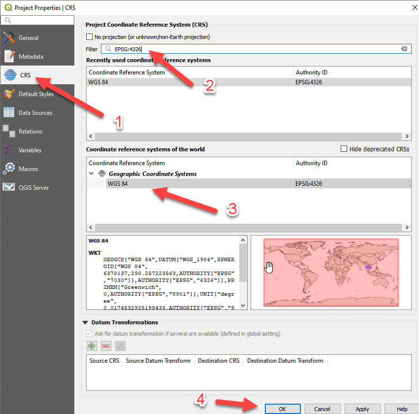
Patiwat Sa-angchai replied to the topic Problem adding scale bar in the forum Week 3 QGIS 5 years, 9 months ago
This cause by QGIS doesn’t know the unit of the map displayed. sorry for project coordinate setting method was skipped.
process to make scale bar display correctly is
1. remove your incorrect scale bar
2. set the project coordinate reference system(CRS)
3. add scale bar again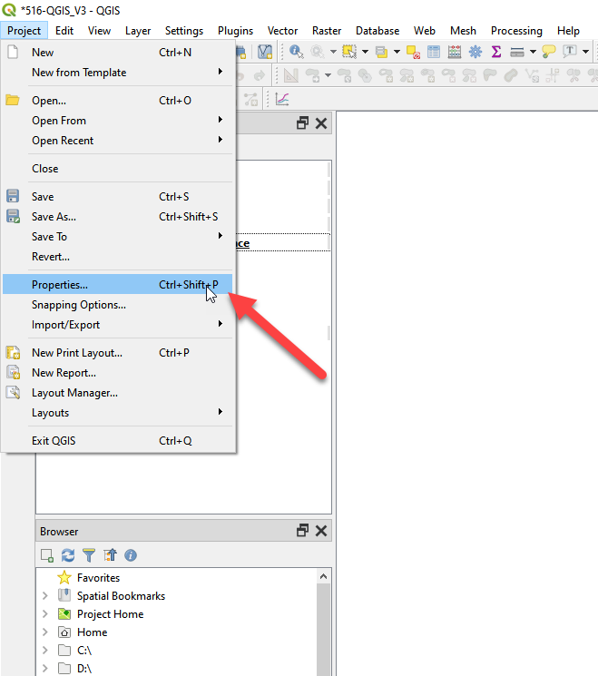
-
Patiwat Sa-angchai replied to the topic I Can not find toggle editing mode.(the icon with pencil) in the forum Week 2 QGIS 5 years, 9 months ago
- Load More